|
|
|
|
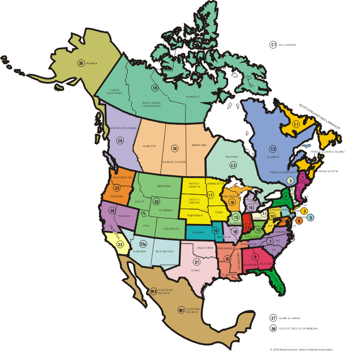
1.
|
Eastern Massachusetts, Rhode Island, New Hampshire, Maine. |
|
2.
|
Connecticut, western Massachusetts, Vermont. |
|
3.
|
New York City, Long Island, Westchester County, New Jersey north of Trenton. |
|
4.
|
Upstate New York. |
|
5.
|
New Jersey, Trenton and south, Pennsyvania east of Harrisburg. |
|
6.
|
Maryland, Delaware, Dist of Columbia, northern Virginia. |
|
7.
|
Southern Virginia, North Carolina, South Carolina,eastern Tennessee. |
|
8.
|
Georgia and Alabama. |
|
9.
|
Florida |
|
10.
|
Western Pennsylvania to Harris, West Virginia |
|
11.
|
Ohio north of Route 40 |
|
12.
|
Ohio south of Route 40, Kentucky |
|
13.
|
Indiana except northwestern counties |
|
14.
|
Michigan and Toledo, Ohio |
|
15.
|
Illinois, north of Rt. 36 and Lake, Porter and LaPorte counties of Indiana |
|
|
|
|
| C1. |
New Brunswick, Nova Scotia, Prince Edward Island, Newfoundland and Labrador. |
| C2. |
Quebec. |
| C3. |
Ontario. |
| C4. |
Alberta, Saskatchewan, Manitoba. |
| C5. |
British Columbia. |
| C6. |
Yukon Territory, Northwest Territories, Nunavut. |
| C7. |
All Canada. |
| M1. |
Eastern Mexico. |
| M2. |
Western Mexico. |
|
|
|
|
|
| 16. |
Wisconsin and Northwestern Michigan (area northwest of Lake Michigan). |
| 17. |
Minnesota. May include North and South Dakota and all or part of Iowa and Nebraska. |
| 18. |
Eastern Missouri, southern Illinois. |
| 19. |
Western Missouri, Kansas. |
| 20. |
Louisiana, Mississippi, Arkansas, western Tennessee. |
| 21. |
Texas and Oklahoma. |
| 22. |
Colorado, Utah. May include Montana, Idaho, Wyoming. |
| 23. |
Southern California* |
| 23a. |
Southern Nevada; Arizona; New Mexico; El Paso, Texas |
| 24. |
California, north of Bakersfield, northern Nevada |
| 25. |
Washington and Oregon |
| 26. |
Alaska |
| 27. |
Hawaii and Guam |
| 28. |
Puerto Rico and Caribbean |
|
|
|
|
* Please note, southern Nevada is often included in territory 23 depending on the industry and other variables. |
|
|
|
| 31. |
International. |
| 32. |
National. |
| 33. |
Central America. |
| 34. |
South America. |
| 35. |
Europe. |
| 36. |
Asia. |
| 37. |
Middle East. |
| 38. |
Continental U.S. |
|
|